Monday, March 25, 2013

Upcoming Group Hike: Starr King Open Space in San Francisco

I recently published a small article about Starr King Open Space in Bay Nature magazine, and was pleased to hear from the editor, Dan, that a well-known lepidopterist in the city was thrilled by it. He'd never been there before and ended up seeing plenty of flowers, including rarities, and even some wildlife.

For the group hike of April 2013, I'd like to bring folks to Starr King Open Space on Sunday April 7th from 11 to 12:30.

Starr King Open Space is on Potrero Hill in San Francisco. It's relatively close to General Hospital, the 101 and 280, 23rd Street, and it was my backyard as I grew up here in the 80s and early 90s. I used to spend hours here, sliding down the hills on pieces of cardboard with other neighborhood kids, walking my dog, or watching the fog drape over Twin Peaks. I'm glad to know the place is protected now, and furthermore that with age you can even notice a lot more than when you were a kid---like seeing all the wildflowers and understanding how rare they are, like the mariposa lily.

We'll ramble around the 3.5 acres that make up this open space, visit a stone spiral in one of the meadows, see rock outcroppings that create a special habitat called serpentine grassland, and have a picnic with an amazing view of the city spread out before us.

Special Guests
Webb Green, Vice President of the Starr King Open Space (http://starrkingopenspace.org), will point out different kinds of wildflowers, many of which are rare and native. He's been on the board for a decade, and active with the land for twenty years. I'm hoping Julie Shumate, the President of SKOS, will attend with her kid, as they're good friends of mine.

Getting There
We will meet under the eucalyptus trees across the street from Starr King Elementary School (1215 Carolina Street, 94107--cross street is Coral Road) on Potrero Hill.

Bus: You can catch the 48 Quintara from 24th Street BART, or the 19 Polk from Civic Center BART---either will take you a few blocks from our meeting spot.

Car: Exit 101 to Cesar Chavez, go north on Potrero Avenue, turn right on 23rd, turn right on Carolina Street, proceed two blocks to Starr King Elementary School, and park.

Relevant Links
http://starrkingopenspace.org
http://www.potreroview.net/news10051.html
http://www.sfgate.com/bayarea/nativeson/article/Enjoy-Starr-King-Open-Space-atop-Potrero-Hill-3518667.php


Map of the Area

View Larger Map

Crystal Springs Trail: dirt, bunnies, and the sound of water

In the past whenever I've visited Crystal Springs Reservoir, I'd only ever walked on the paved trail, Sawyer Camp Trail, the one full of joggers and walkers galore, whizzing bikes, and a flotilla strollers. Sawyer Camp Trail is just north of 92--but I've always wondered about the possibility of trails south of Highway 92? 

I'm not a lover of concrete, especially when I'm want to be outdoors, so it's with great pleasure I tell you about Crystal Springs Trail, a dirt trail just south of Highway 92
Crystal Springs Reservoir
Crystal Springs Reservoir, for those who aren't familiar with it, is right off I-280 to the west of San Mateo, just 20-something miles south of San Francisco. It's a beautiful place for a man-made lake, and its clean, blue waters come from local creeks and from as far away as Hetch Hetchy in Yosemite. The  the forests and mountainous ridge to the west are pristine without houses or roads.
"Spring Fog" by Christina Puckett. Cordair.com

This is a great place to see advection fog at work too--that incredible natural wonder where the fog slides over the hills in a thick white blanket. Come late in the afternoon or the morning for the best chances of seeing this.

Perhaps the biggest drawbacks to walking along Crystal Springs Reservoir is the continuous fence (but you start to forget about it here and there), and the droning of single-engine prop planes en route to the tiny airport in Half Moon Bay / Princeton Harbor, but these distractions are intermittent. Mostly, you see the flowers and the fields, the cottontails and the raptors, and hear the songbirds and the water hitting the shore. 

Such a pretty trail compared to concrete ones
The Trail
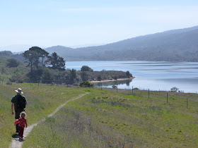
Crystal Springs Trail gets you much closer to the water than the popular and paved Sawyer Camp Trail. Because Crystal Springs Trails is dirt, it somehow seems to repel people---on a busy Sunday there was just our family and a few joggers.

This one, then, is the gem.

You can actually hear water lapping on the shore, see beaches, and get close to wildlife. During one snack break, cottontails foraged under the coyote brush while overhead hawks and vultures flew.

Lupine
We only walked about a mile, past a large oak tree and a crude bench, though our map showed that 1.8 miles from where we parked was the Pulgas Water Temple, a stone structure with Greek architectural elements that was built to celebrate the fact that folks could get water all the way from Hetch Hetchy in Yosemite to here. (It's good to note that there are bathrooms at the Pulgas Water Temple.)

At this time of year, late March, there were wildflowers galore: purple colored lupine, buttercups, California golden poppies, and many more. The serpentine rocks along part of the way nurture native plants because of the chemicals they impart to the soil, and I think I saw goldfields there. We passed tons of coyote brush throughout. There was also coffee berry, oak trees, and plenty of poison oak and blackberry along the fence edges.

Teasel
The trail was flat with a little undulation. An outdoors type stroller could easily traverse this, and our 3.5 year old managed to go about two miles roundtrip before self-combusting.


Directions
Drive south of San Francisco on 280 for about 22 miles. Exit at 92 heading west. Park on Canada Road, which crosses 92. You will be on the east side of the reservoir.

Park at the southwestern corner of the intersection between Canada Road and Highway 92; there are plenty of parking spaces. A narrow dirt trail swings down at either end of the parking area to the main walking trail alongside the fence.

No facilities, except at the Pulgas Water Temple.

Of particular interest to bicyclists, check out Canada Road on Sunday when it closes to motorized traffic between H-92 and Filoli (approximately 2.5 miles). It's called Bicycle Sunday, and the open road is all yours.
Map of Crystal Springs Trail, courtesy http://www.co.sanmateo.ca.us

*                                              *                                           *     

PHOTO ALBUM