 |
India Basin
|
I.
A great thing is in the works in San Francisco: The Blue Greenway, a twisting path running down the bayside edge of The City from the baseball stadium to the curve of broken-rubble beach down by the old football stadium. It's not here yet--but it's on its way. This thirteen-mile section is part of a 500-mile grand plan of trails proposed for “waterfront walking and bicycling paths” along the jagged perimeter of San Francisco Bay.
On one hand, I fear it taking ages to happen. Nearly a decade has passed since the Blue Greenway was first proposed back in 2003. But then again, the wheels have been turning, and progress will continue, especially if more local people get involved.
San Francisco Chronicle writer Will Kane spread the word in early November of 2010 that the Neighborhood Parks Council received a $175,000 grant from the Environmental Protection Agency to “research the best way to build [the] 13-mile path, called the Blue Greenway.”
There’s a call to action. Jane Diamond, Director of EPA’s Pacific Southwest Regional Superfund Division, says the money is also intended “to help residents more fully participate in planning efforts.” Now I’ve just got to find my way to knock on that door.
II.
As a child growing up on Potrero Hill, sometimes my mom would take my sister and I to see a friend who lived down by the bayside at a place we called Shit Creek. The creek’s unfortunate name didn’t start with us; back in the days of the Gold Rush and Butchertown, the quaint name for this neck of the woods, folks dumped odds and ends of cattle carcasses here, shit, blood, trash, you name it. In the hundred and fifty odd years since those days, auto parts places, scrap metal yards, paint shops, and specialty hardware stores moved in, bringing their sweet mix of ingredients to the stew. I was a kid in the 1970s and ‘80s, feeding scraps of bread to birds floating on an iridescent, rainbow sheen of water, blissfully unaware.
As a teen with a bicycle, and then a car, I sometimes went down to the eastern edge of The City, to warehouses located where landfill meets water, and stayed up all night to music I didn’t care about, clustered with groups of young people at the edge of the abandoned MUNI bus yard, befriending one-eyed stray cats slinking under the bushes, warming our hands around small bonfires. By night, this part of town was dark and abandoned, half the streetlights off, and just a few cars going too fast down Third Street. If someone asked me, “What was San Francisco like before all this?” I would’ve said it was marshland. I had learned that in school. But I loved the abandoned buildings, the idea that I could traipse through them like a secret voyeur, like my friends and I were the last people on earth, throwing stones and painting pictures till arms grew tired. And still, I was blissfully unaware.
To realize the essentiality of marshland, I needed decades to pass. Years of working for someone else, for classrooms full of kids. Years of intensely loving other people, and then of losing them. Years of sitting in classrooms and lecture halls, or crouched over a book or computer, learning factoids like 90% of San Francisco Bay has been altered for the worse by mankind.
“You don’t miss the water till the well runs dry,” sang an R&B artist from the 1960s. The words couldn’t be more apt.
And it took a baby; where once I was like, okay, it’s marshland, so what? Landfill schmandfill. What can I do? What can I really do when it’s so easy for someone to press buttons and unleash weapons and blow the whole place up. My baby and I might not survive World War III, but damned if I can’t try to make things better now. Sometimes I wonder if planting that one seed, of literally touching that one rubbery tip of pickleweed growing at the edge of the development site, of chancing upon a heron stalking minnows in the eel grass, if that’s the last moment we have. If it’s the only thing I have, let it be.
 |
| Heron's Head Park |
III.
What happens when a marshland goes dry? When man fills her up with his trash and quarried rock?
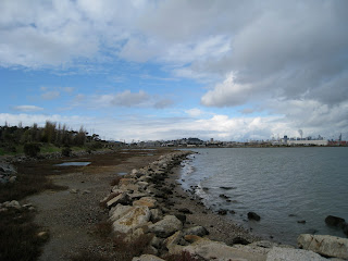
Recently my husband and I went down to the waterfront in Hunter’s Point, a neighborhood next to our more southern neighborhood, Visitacion Valley. We went to see one of the “parks” that the Blue Greenway will connect (the greenest spaces right now, by the way, going from north to south, are China Basin, Agua Vista, Islais Creek (aka Shit Creek), Pier 94 Wetlands, Heron’s Head, India Basin Shoreline, and Candlestick Point State Recreation Area). A family of young parents and their kids picnicked at India Basin. Other than them and us, it was just the birds—brown pelicans, plenty of gulls, long-legged shorebirds whose names I have yet to learn, and little brown seedeaters darting from bush to bush. A veritable graveyard of small, paint-peeling boats rested on the water next to old shacks; this be Popeye’s territory.
Next door in the other direction big machines thrummed in the old naval shipyard, and bright yellow booms floated in crescent shapes just off shore, containing unknown toxic crap in their arm-hold. Clean up has been a long time coming, but its here, spearheaded I believe by Lennar, a Florida-based development company. They’re building over 10,000 units on the landfill of the old shipyard. It shall be a vast commune of condos—far better than a toxic shipyard, in my opinion, but worse than just cleaning up the land and restoring marshland.
IV.
In 1849 the Swamp Land Act allowed and encouraged people to “reclaim” the wetlands. This Act, plus a couple of subsequent ones, granted California 2,192,875 acres for “swamp reclamation.” Nice going, Forebears. A relatively recent inventory of California marshland, as detailed by the Fish and Wildlife Service, tallies us at 457,000 remaining wetland acres.
I guess nobody knew what they meant when they talked about reclaiming wetlands. The shoulders shrugged and the pickaxes swung. Who knew the wealth of a marshland? That its matted rooty tangles could filter pollutants, or give refuge to baby fish? That birds needed to rest here. That water was contained and somewhat cleansed here. Who knew?
 |
| At India Basin |
And if I knew San Francisco had marshlands, did I care when the mortgage payment kept me working like a dog? Bitter fish grow legs and live on land, you see. But now the pull of the sea draws me back to the waterfront.
According to the group Save the Bay, we can bring wetlands back. It’s really a choice. They say we need to have 100,000 acres of marshland here in San Francisco Bay. When Save the Bay started in 1961, there were only five miles of “publicly accessible shoreline”—now there are 300 miles.
 |
| Pickleweed |
How does one change an environmental tragedy? How does one like me, who is learning a little too late in life, do something with tangible results? Sometimes all I want to do is sit on the rotted dock and watch the moon rise over the Oakland hills. Sometimes all I want to do is complain.
Perhaps the big change takes one pickleweed plant at a time. (Jeez, it’ll take forever, the curmudgeon in me whines.) Perhaps each pocketful of bottle caps picked up by a waterfront wanderer will make a difference.
With seven million residents in the Bay Area, there’s a lot of possibility. But we just want our gourmet burritos, our winding streets, our iconic image of fog pushing over the peaks, our bridges.
V.
The industrial southeastern side of SF is not the first place I’d have imagined a waterfront part. Now I can’t help but imagine a trail there. Call it the Blue Greenway, call it our last chance. Peel off the concrete like a scab.
I see a shoreline made of mud instead of concrete, filled with thousands of shrimp, crabs, worms, clams, and snails, instead of polystyrene bits and bottle caps. And the birds on their epic migrations will be here, as well as the resident species. May the eelgrass and pickleweed grow. May a zillion baby fish be born and thrive here. May the nearly unseen bits of plankton, the shimmery diatoms and larva and dinoflagellates, drift along our waterfront and be touched by sunlight instead of rainbow oil.
 |
| Heron's Head |
“If I had the influence with the good fairy who is supposed to preside over the christening of all children I should ask that her gift to each child in the world be a sense of wonder so indestructible that it would last throughout life, as an unfailing antidote against the boredom and disenchantments of later years, the sterile preoccupation with things that are artificial, the alienation from the sources of our strength.” --Rachel Carson (1907-1956)
 |
| Naval shipyard |
 |
| India Basin |
 |
| Egret at Heron's Head |
 |
| San Francisco from a boat |
 |
| Candlestick Park |
 |
| Old fishing pier at Candlestick Park |
 |
| Raven at Candlestick Park |
 |
| "Mudflats" at Candlestick Park |
 |
| Yosemite Slough |
 |
| By the entrance to Heron's Head Park |
Sources:
Alexander, Jean. “A bird’s eye view of The Blue Greenway.” Neighborhood Parks Council. 2003-2007. Retrieved 11/24/10.
Armstrong, P.; Connor, J.; Parsons, C.; Rand, J.; Vuturo-Brady, J. Sea Searchers Handbook. Monterey: Monterey Bay Aquarium Foundation, 1996.
Kane, Will. “13-mile path to revitalize industrial waterfront.” San Francisco Chronicle. November 11, 2010.
Neigborhood Parks Council Press Release, “San Francisco’s Blue Greenway Gains National Recognition & Support from EPA.” November 10, 2010.
Save the Bay 50th Anniversary 2011 Calendar. “Fun Facts of the San Francisco Bay-Delta Estuary.” Save the Bay, 2010.
USGS. “Wetlands of the United States: Their Extent and Their Value To Waterfowl and Other Wildlife, A Century of Wetland Exploitation.” 2006. Retrieved 11/26/10.
View Larger Map


